

Discover the Light Pollution Map App: Your Guide to Clear Night Skies
Have you ever gazed at the night sky, only to be disappointed by the limited visibility of stars due to light pollution? You're not alone. As urban areas continue to grow, excessive artificial lighting hampers our ability to enjoy the beauty of the cosmos. That's where the Light Pollution Map app comes into play—a powerful tool designed to help stargazers, astronomers, and curious explorers find the best locations for observing the night sky or even locating the perfect piece of land for stargazing adventures. Whether you're a seasoned astronomer or a casual night sky enthusiast, this app provides invaluable insights that can transform your celestial experiences.
Key Features and Functions of the Light Pollution Map App
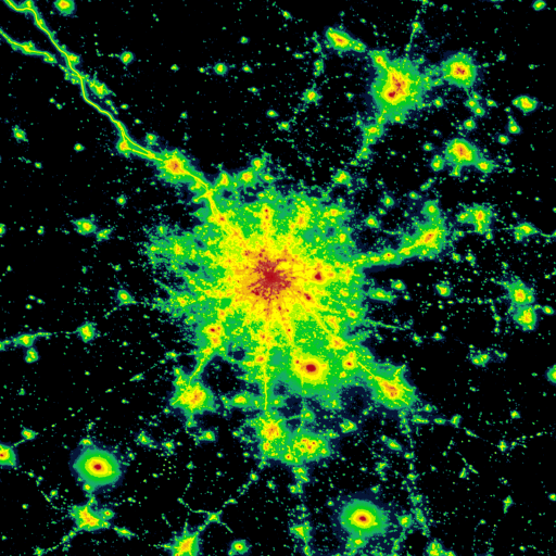
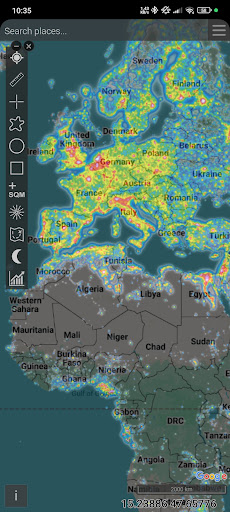
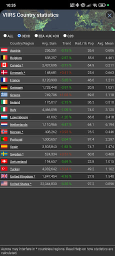
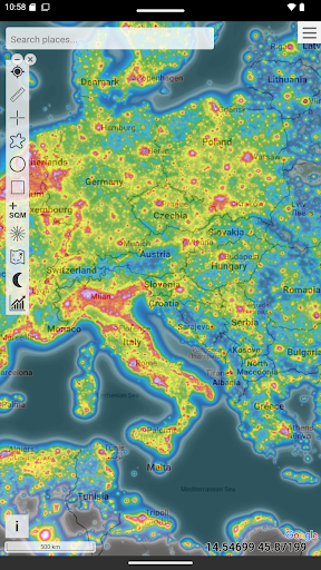
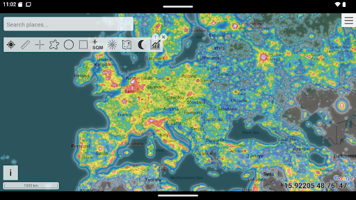
The Light Pollution Map app offers an array of features that make it a must-have for anyone interested in light pollution and stargazing. Its interface is intuitive and user-friendly, featuring an interactive map that displays broad and detailed overlays of light pollution data sourced from various satellite systems such as VIIRS, DMSP, and the World Atlas. These overlays are color-coded and easily distinguishable, with options for color-blind friendly visualizations to accommodate all users.
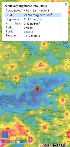
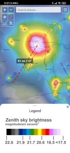
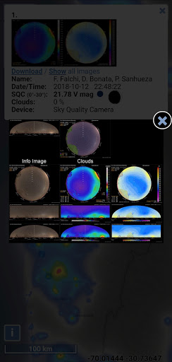
One of the standout aspects of this application is its ability to provide real-time data on sky brightness, cloud coverage, and aurora forecasts. Users can view these overlays on top of Bing maps—be it road maps or hybrid satellite images—making it easy to plan night's outings. The app’s detailed radiance measurements, such as SQM (Sky Quality Meter) and other community-submitted readings, offer precise insights into light levels at specific locations. Moreover, dedicated layers show observatories, providing an excellent resource for those seeking dark skies for serious astronomical observation.
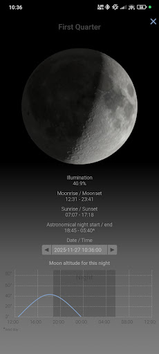
Another compelling feature is the offline mode, which allows you to save maps and essential data directly onto your device. This capability means you can access crucial information even without an internet connection—ideal for remote or rural night sky expeditions. The app also includes functionalities like saving favorite spots, measuring distances, and estimating the Bortle class—a useful scale indicating the quality of the night sky in different areas.
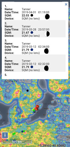
For community engagement, users can submit their own SQM readings or report light pollution changes, ensuring the data remains current and accurate. If you have a permanent SQM device, you can send measurements directly to the developers to enhance the map's precision. With forecast layers for clouds and auroras, users can plan nights based on upcoming conditions, optimizing their chances for successful stargazing sessions.
One of the standout aspects of this application is its ability to provide real-time data on sky brightness, cloud coverage, and aurora forecasts. Users can view these overlays on top of Bing maps—be it road maps or hybrid satellite images—making it easy to plan night's outings. The app’s detailed radiance measurements, such as SQM (Sky Quality Meter) and other community-submitted readings, offer precise insights into light levels at specific locations. Moreover, dedicated layers show observatories, providing an excellent resource for those seeking dark skies for serious astronomical observation.
Another compelling feature is the offline mode, which allows you to save maps and essential data directly onto your device. This capability means you can access crucial information even without an internet connection—ideal for remote or rural night sky expeditions. The app also includes functionalities like saving favorite spots, measuring distances, and estimating the Bortle class—a useful scale indicating the quality of the night sky in different areas.
For community engagement, users can submit their own SQM readings or report light pollution changes, ensuring the data remains current and accurate. If you have a permanent SQM device, you can send measurements directly to the developers to enhance the map's precision. With forecast layers for clouds and auroras, users can plan nights based on upcoming conditions, optimizing their chances for successful stargazing sessions.
Ease of Use and Accessibility
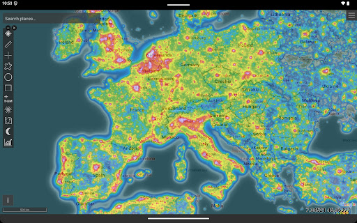
Getting started with the Light Pollution Map app is straightforward. Simply download it on your Android or iOS device, grant your location access, and the app will automatically identify your current position. From there, it displays light pollution intensity at your location and across surrounding areas. Users can explore different regions by zooming and dragging the map, making trip planning or land searching effortless.
The settings are highly customizable—allowing you to toggle various overlays such as weather conditions, astronomical events, and different map styles. The app's convenience is further enhanced by features like animated cloud layers for the past 12 hours, providing insights into weather patterns that might impact stargazing. Whether you're indoors planning your next night trip or out in the field, this app adapts to your needs, offering detailed data with just a few taps.
The settings are highly customizable—allowing you to toggle various overlays such as weather conditions, astronomical events, and different map styles. The app's convenience is further enhanced by features like animated cloud layers for the past 12 hours, providing insights into weather patterns that might impact stargazing. Whether you're indoors planning your next night trip or out in the field, this app adapts to your needs, offering detailed data with just a few taps.
Why Choose the Light Pollution Map App?
In a world where city lights continually obscure our view of the stars, the Light Pollution Map app acts as a beacon for astronomy lovers and casual stargazers alike. It seamlessly combines satellite data, community contributions, and advanced mapping tools to provide a comprehensive view of light pollution levels worldwide. This empowers users to seek out darker skies—whether for professional astronomical research, astrophotography, or simply enjoying a peaceful night under the stars.
The app’s versatility—featuring offline capabilities, detailed overlays, community-driven updates, and forecast tools—ensures that you'll always have the necessary information for a successful night under the celestial canopy. So, if you're eager to reconnect with the universe, download the Light Pollution Map app, find your ideal dark spot, and let the universe unveil its wonders in the clearest, most stunning way possible.
The app’s versatility—featuring offline capabilities, detailed overlays, community-driven updates, and forecast tools—ensures that you'll always have the necessary information for a successful night under the celestial canopy. So, if you're eager to reconnect with the universe, download the Light Pollution Map app, find your ideal dark spot, and let the universe unveil its wonders in the clearest, most stunning way possible.
Pros
- Provides real-time data on light pollution levels.
- Offers highly accurate and dependable measurements.
- Features an intuitive interface for straightforward navigation.
- Allows customizable map views to suit individual needs.
- Supports offline access to saved maps.
Cons
- Dependent on internet connection for live data updates.
- May consume significant battery power on mobile devices.
- Limited features available in the free version.
- Can be intimidating for new users to learn.
- Occasional issues with map loading glitches.