Frequently Asked Questions
What is the purpose of the Light Pollution Map app?
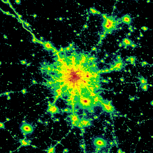
The Light Pollution Map app helps users identify areas with different levels of light pollution. It is especially useful for astronomers, stargazers, and photographers who want clear night skies. The app provides real-time data on light pollution to assist users in finding optimal locations for nighttime activities.
How accurate is the data provided by the Light Pollution Map app?
The app compiles data from trusted sources such as satellite images and local monitoring stations to deliver current and precise information on light pollution levels. While the app aims for high accuracy, environmental factors and urban development may influence real-time results.
Is the Light Pollution Map app user-friendly for beginners?
Yes, the app features a user-friendly interface that is simple to navigate. Its intuitive tools and clean design make it accessible for users of all experience levels, from novices to experts.
Does the Light Pollution Map app require an internet connection to function?
Yes, an internet connection is needed to access real-time light pollution data and updates. Nonetheless, users can download specific maps for offline use, allowing access to key information in areas without connectivity.
Are there any costs associated with using the Light Pollution Map app?
The app offers a free version with basic features. Users can upgrade to a premium subscription for additional benefits such as ad-free experience, advanced data layers, and customization options. The premium version provides more detailed insights and a richer user experience.
You May Like

Waze Navigation & Live Traffic
Maps & Navigation
4.1
Sygic GPS Navigation & Maps
Maps & Navigation
4.2
Radarbot: Radar Detector, GPS
Maps & Navigation
4.1
Grab Driver: App for Partners
Maps & Navigation
3.9
Yango: taxi, food, delivery
Maps & Navigation
4.8
Careem: rides, food, grocery
Maps & Navigation
4.2
Lyft
Maps & Navigation
4.2
MarineTraffic - Ship Tracking
Maps & Navigation
4.4
Radar, HUD, Map, Speed Camera
Maps & Navigation
4.4
Phone Number Location
Maps & Navigation
4.1
Compass: Accurate Compass
Maps & Navigation
4.7
Phone Tracker & GPS Location
Maps & Navigation
3.5