


Discover the World with GPS Earth Live Satellite Maps
Are you eager to explore the vast beauty of our planet right from your phone? GPS Earth Live Satellite Maps is a powerful and innovative tool designed to bring the world to your fingertips. With its array of cutting-edge features, this app transforms your device into a personal exploration and navigation assistant, making travel planning, discovery, and sightseeing more engaging and effortless than ever before.
Key Features of GPS Earth Live Satellite Maps
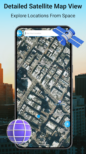
High-Definition Satellite & Earth Maps
Experience detailed 3D maps of any location with high-definition satellite & earth views. The app provides real-time, satellite imagery in stunning quality, allowing you to explore the globe with clarity. It includes aerial views and live satellite street views, giving a comprehensive perspective of urban landscapes and natural sites alike.
AI-Powered Exploration
Maps integrated with artificial intelligence enhance your travel experience by offering instant details about any location. Simply ask AI about a place, and get in-depth information, latitude & longitude coordinates, and even plan your visit seamlessly. The AI assistant acts as a personal tour guide, enriching your journey with relevant insights and suggestions.
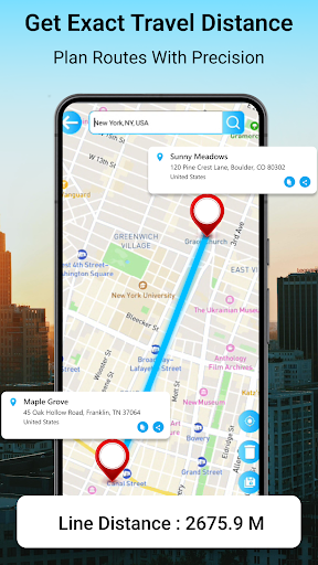
Real-Time Navigation and Routing
Navigate effortlessly with live traffic maps and optimized routes. Whether you're driving, walking, or navigating public transit, GPS Earth Live Satellite Maps helps you find the shortest and fastest routes to your destination. Inbuilt tools like speedometer, compass, and speed alerts ensure a smooth and safe journey.
3D Earth and Building Visualization
The app features a real 3D earth map that provides an immersive experience, displaying 3D buildings and terrains. This helps users better understand any location’s layout, scale, and architecture, making it an ideal tool for tourists and travelers.
Additional Travel Tools
Advanced travel tools like the address finder, route saver, and favorite locations make your journeys easier and more organized. Save your preferred destinations and routes for quick access later, ensuring you never lose track of memorable spots or essential addresses.
Enhance Your Travel Experience
GPS Earth Live Satellite Maps is not just a navigation app—it's a comprehensive travel kit. Discover top tourist attractions in aerial view or live street view, plan your tours efficiently, and explore the globe with detailed satellite imagery. The app's ability to display latest satellite images ensures you see the most current view of any location, making your virtual exploration as authentic as possible.
Enjoy More Than Just Maps
The app offers features like live traffic updates that can help you avoid congestion and optimize your travel time. With tools such as real-time speed monitoring, alerts, and easy address lookup, GPS Earth Live Satellite Maps keeps your journey safe, efficient, and informative. The user-friendly interface ensures that even first-time users can navigate effortlessly, making travel planning and exploration a fun experience.
Why Choose GPS Earth Live Satellite Maps?
As a complete travel companion, GPS Earth Live Satellite Maps combines the power of high-definition satellite imagery, AI-driven insights, and intuitive navigation tools. It simplifies the process of exploring new places, finding routes, and visualizing destinations—whether for planning trips, discovering new locations, or just satisfying curiosity about the world.
Conclusion
In today’s digital age, exploring the world has become easier and more immersive with apps like GPS Earth Live Satellite Maps. Its ability to provide detailed, real-time satellite views, integrated AI assistance, and comprehensive travel tools make it an indispensable companion for adventurers, travelers, and curious globetrotters alike. Download this app today and unlock a world of exploration right from your device, turning your travel dreams into real-world adventures.
Pros
- High-resolution satellite imagery
- User-friendly interface
- Real-time GPS tracking
- Offline maps available
- Frequent updates
Cons
- Requires internet connection for live updates
- May consume battery quickly
- Some features require payment
- Limited 3D viewing options
- Advertisements can be disruptive