
Discover the Power of onX Hunt: Offline Hunting Maps
If you’re passionate about hunting and want to elevate your outdoor adventures, the onX Hunt: Offline Hunting Maps app is your ultimate companion. Designed to provide detailed navigation tools, land ownership data, and other essential features, this app transforms your smartphone into a comprehensive hunting assistant. Whether you're tracking game species, exploring new terrains, or planning your next trip, onX Hunt offers the tools you need to hunt smarter and more efficiently.
Main Features of onX Hunt
Navigate with Confidence Using Detailed Maps
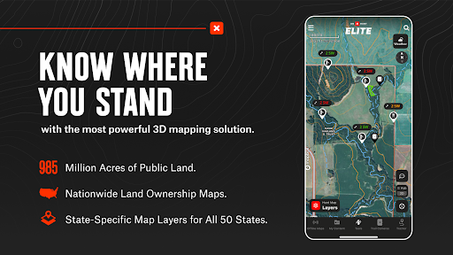
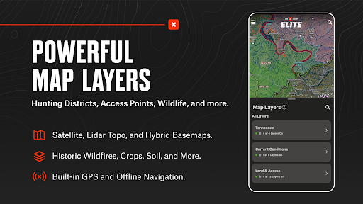
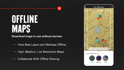
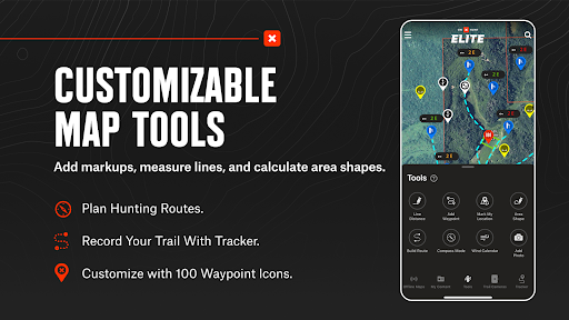
onX Hunt provides an array of topographical and satellite maps that help you understand terrain features and plan your route effectively. View topo maps, switch seamlessly between satellite and hybrid basemaps, and even open 3D maps to get a realistic perspective of the land. The ability to mark Waypoints for key locations, measure distances with the tool Lines, and record routes ensures you stay organized and aware of your surroundings. Download Offline Maps to access detailed maps in remote areas where cellular service is unavailable, giving you confidence in every step you take.
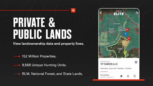
Land Ownership and Hunting Units
One of the standout elements of onX Hunt is its detailed data on public and private land boundaries. With access to landowner names and property lines, hunters can navigate with confidence, respecting land boundaries and seeking out new opportunities. The app also displays Hunting Units or GMUs, allowing you to plan your hunts based on specific regulations and designated areas. This feature is invaluable for both seasoned and novice hunters aiming to maximize their success.
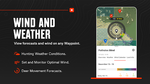
Species, Weather, and Wildlife Data
Easily filter maps to focus on specific wildlife like deer, elk, turkeys, or waterfowl, improving your chances of finding game. Additionally, real-time weather updates offer vital information on wind conditions, temperature, and forecasts, helping you decide the best time and spot for your hunt. Switch between custom Map Layers that display wildlife distribution, trees, crops, or soil types—each providing critical insights into animal movements and habitats.
Advanced Hunting Tools
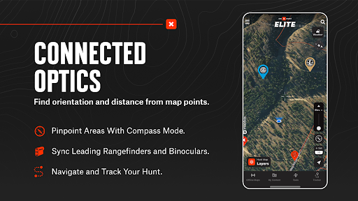
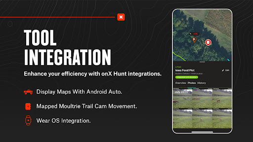
Link your trail cameras directly to the app to observe recent activity with real-time trail camera images. Use built-in tools like measuring distance between points, mapping routes, planning wind directions, and marking access points—all essential for strategic hunting. The app also integrates with Wear OS devices, allowing you to drop Waypoints directly from your smartwatch, enhancing hands-free navigation.
Personalized Planning and Tracking
onX Hunt helps you prepare before heading into the field with its Hunt Planner and Tracker. Save critical Waypoints and routes, monitor your hunt duration, speed, and distance, and access in-depth maps from your desktop for planning purposes. Connect your trail cameras to see recent game activity, optimizing your chances for a successful hunt.
Membership Options for Every Hunter
Start your journey with a free trial and upgrade to Premium, Premium+, or Elite Nationwide Memberships. The most comprehensive plan offers proprietary maps for all 50 states and Canada, advanced tools like TerrainX 3D Viewer and Recent Imagery, and exclusive features such as in-dash navigation with Android Auto. These memberships are designed to cater to the needs of dedicated hunters seeking the ultimate digital hunting assistant.
Access to Government Data
While onX Hunt does not originate from government agencies, it provides links to public datasets from reputable sources like the US Forest Service and BLM. This integration ensures you have access to authoritative information on land management, wildlife areas, and geographic data, helping you make informed decisions in the field.
Why Choose onX Hunt for Your Hunting Expeditions?
The onX Hunt app is more than just a mapping tool; it’s an all-in-one platform that enhances every aspect of your hunting experience. Its detailed land ownership maps, offline capabilities, real-time weather updates, and advanced navigation features make it indispensable for hunters aiming to find new access points, track game more effectively, and hunt more responsibly. Whether hunting locally or exploring new territories across the country, onX Hunt equips you with the recon tools necessary for a successful outing.
Final Thoughts
For avid hunters looking to maximize their efficiency and success, onX Hunt: Offline Hunting Maps offers an impressive suite of features designed to streamline planning, navigation, and data analysis. Its comprehensive maps, land boundary data, and weather tools are tailored to help you hunt smarter, safer, and more responsibly. With its intuitive interface and powerful capabilities, onX Hunt is truly the digital partner every serious hunter needs in the field.
Pros
- Access to detailed topographic maps.
- Availability of offline maps for remote locations.
- Real-time sharing of your location.
- Ability to customize waypoints and routes.
- Extensive information on public and private lands.
Cons
- Premium features require a subscription.
- Interface may be complicated for new users.
- Limited features in the free version.
- May cause significant battery consumption over extended use.
- Certain maps need regular updates.
You May Like

Carrom Pool: Disc Game
Sports
4.6
Pooking - Billiards City
Sports
4.5
EA SPORTS FC™ Mobile Soccer 26
Sports
4.7
LiveScore: Live Sports Scores
Sports
4.8
Da Fit
Sports
4.7
Sofascore: Live Sports Scores
Sports
4.9
OneFootball: All Soccer Scores
Sports
4.8
365Scores: Live Scores & News
Sports
4.6
Parkour Race - FreeRun Game
Sports
4.7
3D Pool Ball
Sports
4.4
Basketball Battle
Sports
4.9
Basket Battle
Sports
4.7