

Discover the Ultimate Navigation Tool with Navionics® Boating
If you’re passionate about exploring open waters, sailing adventures, or simply enjoying a day on the boat, Navionics® Boating is the app you’ve been waiting for. While many boating apps are available, Navionics® stands out with its impressive suite of features designed to enhance your maritime experience. Whether you’re a seasoned sailor or a casual water enthusiast, this application combines cutting-edge technology with user-friendly design to become your essential navigation companion.
Intuitive Interface and Detailed Offshore Charts
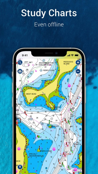
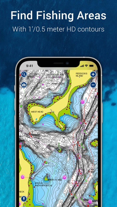
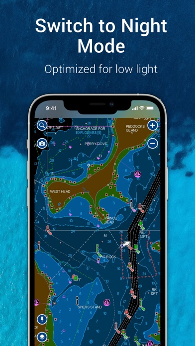
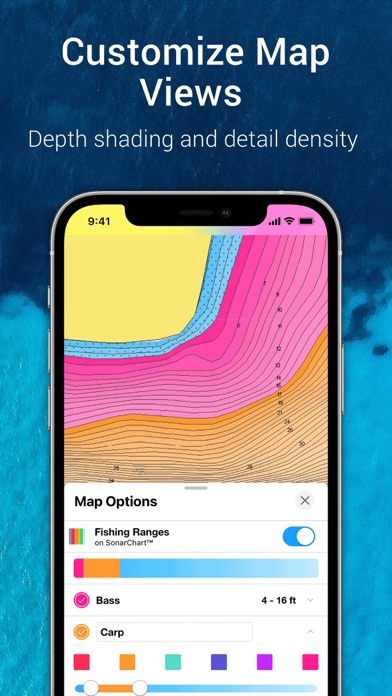
Upon launching Navionics® Boating, users are greeted with an intuitive and visually appealing interface. The app caters to a wide range of users, from beginners to experts, making navigation straightforward and hassle-free. One of its core strengths is the access to •Internationally renowned Navionics® charts. These detailed nautical maps are available for offline use—crucial for remote areas where cellular signals are weak or unavailable. The charts include multiple layers such as the •NAUTICAL CHART, which offers insights into port plans, anchorages, safety depth contours, navigation aids, and marine services. Additionally, the •SONARCHART™ HD Bathymetry Maps provide high-resolution (1’ or 0.5 meter) bottom contours, helping you locate top fishing spots or explore underwater terrain with accuracy. The app also integrates •U.S. Government Charts (NOAA) covering regions like the U.S., Canada, Mexico, Caribbean, and more. For enhanced visibility, overlay options like relief shading and sonar imagery reveal underwater features with vivid detail, making fishing and diving activities more productive and enjoyable. Moreover, users can customize their view with options to switch overlays, activate night mode, or highlight shallow areas, providing a personalized navigation experience complete with daily updates to keep maps current.
Powerful Planning and Water Activities Tools
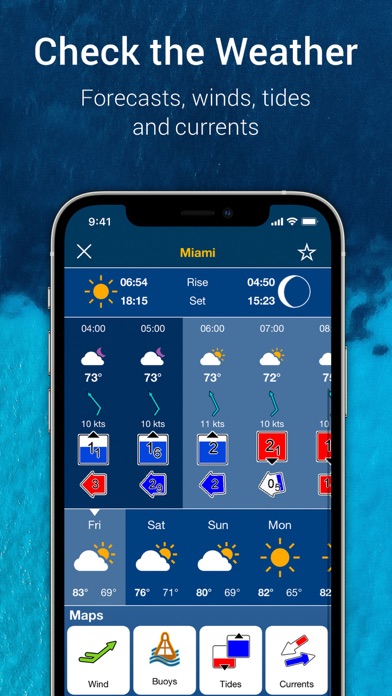
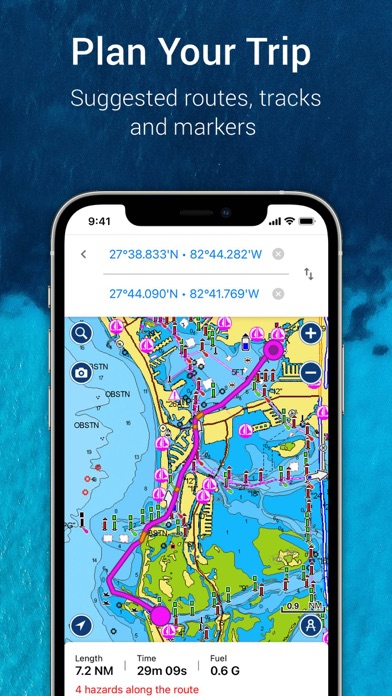
Navionics® Boating offers numerous tools to enhance planning and recreational activities on the water. The •Auto Guidance+™ Technology allows for effortless trip planning with suggested dock-to-dock routes based on your charts and navigation aids. It provides useful data such as estimated time of arrival, distance, heading to waypoints, and fuel consumption, acting as a smart virtual navigator. For better decision-making, real-time •Weather and Tides data are integrated directly into the app, giving access to current conditions, forecasts, wind data, tidal info, and currents—crucial for safe and enjoyable trips. Users can also place markers at favorite spots, record tracks of their journey, and even capture photos and videos along the way, which can be revisited anytime. Features like measuring the distance between points make route adjustments straightforward, ensuring your water adventures are smooth and well-prepared.
Vibrant Community and Sharing Capabilities
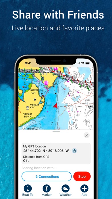
One of the app’s standout features is its active •Community Edits and the ActiveCaptain® Community, where boaters share local insights, points of interest, navigation aids, and hidden gems. This collaborative element turns Navionics into more than just a GPS tool—it becomes a hub of collective knowledge. Stay connected by sharing your live location, routes, markers, and tracks with friends or fellow boaters, making rendezvous on the water easier. The app supports •GPX import/export functions, so you can transfer your navigation data to other devices or chartplotters. Furthermore, sharing locations such as marinas or repairs shops outside the app fosters a community-driven navigation experience.
External Device Compatibility and Advanced Features
For those with compatible hardware, Navionics® Boating seamlessly syncs with chartplotters via •Plotter Sync, allowing route transfers, marker updates, and subscription management. The •SonarChart Live Mapping Feature enables real-time map creation while navigating—ideal for anglers and explorers wanting custom maps. Additionally, connectivity with AIS receivers provides live marine traffic updates, visual and audible collision alerts, and enhances navigational safety, especially in busy waterways.
Why Navionics® Boating Is a Must-Have for Water Enthusiasts
In conclusion, Navionics® Boating combines comprehensive, regularly updated marine charts with advanced planning tools, community insights, and device compatibility to deliver an exceptional navigation experience. Whether you’re planning an offshore fishing trip, scenic sailing, or just exploring new waters, this app offers reliable, detailed information right at your fingertips. Its ease of use and powerful features make it perfect for all levels of boaters, transforming every outing into a safer, more enjoyable adventure. If you love the water and crave a smarter way to explore, Navionics® Boating could very well become your trusted onboard companion. Set sail confidently and make your water adventures unforgettable!
Pros
- Comprehensive nautical charts.
- Real-time weather updates.
- User-friendly interface.
- Offline map access.
- Community edits for accuracy.
Cons
- High subscription cost.
- Limited free features.
- Battery drains quickly.
- Occasional app crashes.
- Requires internet for updates.


