

Introduction to Tactical NAV
If you have ever found yourself in the middle of nowhere, trying to determine your exact location or plan a tactical move without the right tools, then Tactical NAV is the app you need. Designed specifically for military personnel, first responders, outdoor enthusiasts, and adventurers, this innovative navigation application offers precise and reliable capabilities that can make all the difference during critical moments. With its focus on high-accuracy positioning, offline functionality, and user-friendly interface, Tactical NAV stands out as an essential tool for those who demand excellence in navigation and mission planning.
What Makes Tactical NAV Stand Out?
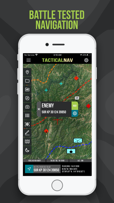
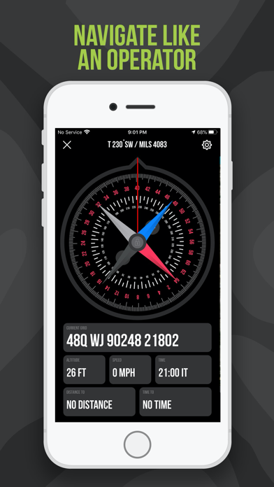
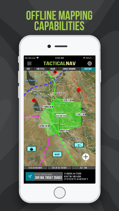
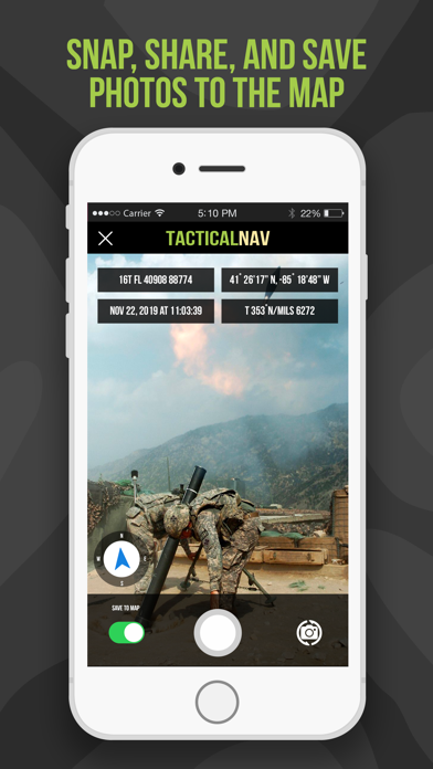
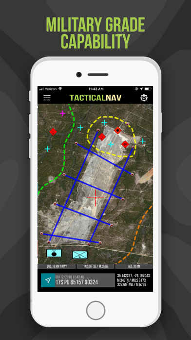
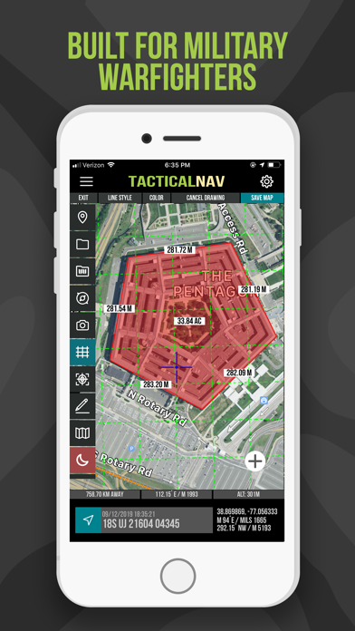
One of the key features of Tactical NAV is its intuitive and easy-to-use interface. Even users with minimal technical experience can quickly learn to navigate the app’s various functionalities. Upon launching, the main screen provides quick access to crucial features such as map overlays, GPS tracking, waypoint marking, and mission planning tools. The straightforward layout ensures that users can focus on their task without unnecessary complexity.A major highlight of Tactical NAV is its military-grade precision. Utilizing the Military Grid Reference System (MGRS) and GPS, the app offers pinpoint accuracy, essential for tactical operations, outdoor expeditions, or any application where every meter counts. In field tests, the app’s accuracy has been verified to be within 1mm of official systems like the AN/PSN-13 Defense Advanced GPS Receiver (DAGR), confirming its reliability even in challenging terrains.Additional features such as offline maps ensure users remain functional in remote locations without cell connectivity. The app's waypoint sharing feature facilitates seamless coordination among team members, enabling real-time collaboration. Moreover, the tactical drawing mode allows users to create overlays, plan routes, and execute precision targeting directly on maps, a vital capability for tactical tasks and mission planning.Customization options further enhance user experience, letting individuals tailor map colors, alert configurations, and other settings according to personal preferences or operational needs. Features like the compass “FastLock” for rapid azimuth capture, photo snapping with geotags, and data sharing via email or messages make Tactical NAV an all-encompassing navigational solution.
Tactical NAV in Action: Key Features
- Military-Quality Precision Targeting Platform: Accurate positioning tailored for tactical operations.
- Designed for the Individual Soldier: Purpose-built for personal use, capturing the needs of military personnel.
- Offline Mapping Capabilities: Use the app without cellular signals, critical for remote or contested environments.
- Standards-Based Coordinates: Supports WGS-84 standard including MGRS, UTM, BNG, and USNG.
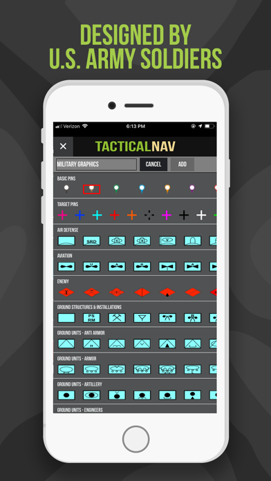
- Tactical Drawing Mode: Build overlays, plan missions, and mark targets efficiently.
- Waypoint Plotting & Military Graphics: Visualize routes and positions clearly, as per FM 1-02.2 standards.
- Quick Azimuth Lock: Capture precise bearings rapidly with FastLock.
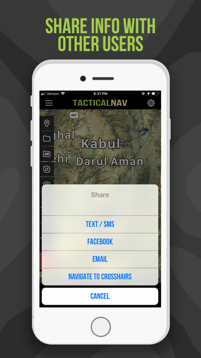
- Photo & Data Sharing: Enhance situational awareness by attaching images, sharing waypoints, and maps.
- “Go to Grid” Function: Precise navigation directly to specific grid locations for tactical planning.
Development and Support
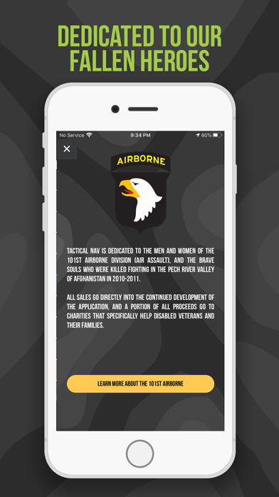
Developed during a combat deployment in Afghanistan, Tactical NAV was created with the memory of fallen soldiers at its core. Initiated by U.S. Army Captain Jonathan J. Springer, the app aims to support modern military and tactical operations by providing high accuracy and robust offline capabilities. Although it is not officially endorsed by the Department of Defense, Tactical NAV undergoes rigorous testing to ensure it meets high standards of performance, matching the accuracy of authorized military systems.The app also features in-app purchases and subscriptions, such as the tactical drawing mode and offline maps, with proceeds supporting charities for disabled veterans. Regular updates continue to improve its features and stability, reflecting the ongoing commitment from the developers to enhance navigational tools for all users.Please note that the Department of Defense does not endorse Tactical NAV, and it should not replace official government-issued devices in life-threatening or combat scenarios.
Conclusion
In summary, Tactical NAV is a powerful navigation app designed to meet the demanding needs of military personnel, first responders, and outdoor enthusiasts who require accuracy, reliability, and offline capabilities. Its suite of features including tactical overlays, waypoint sharing, and precise coordinate handling makes it an invaluable tool for mission planning, tactical operations, and outdoor adventures. Built with a focus on purpose-driven design and field-tested performance, Tactical NAV stands out as an essential application for anyone who values precision navigation in the most challenging environments.
Pros
- Provides comprehensive GPS navigation suitable for military purposes.
- Enables real-time location sharing with team members.
- Allows customizable map overlays for effective mission planning.
- Supports offline maps for use in remote areas.
- Features a user-friendly interface for quick and easy access.
Cons
- Limited features available in the free version.
- Requires regular updates to maintain map accuracy.
- Consumes a high amount of battery during use.
- Can be complicated for users without military experience.
- Potential security risks related to data privacy.


