
Discover PeakVisor - Your Ultimate Mountain Navigation Companion
PeakVisor is a powerful mobile application designed to transform your outdoor adventures. Whether you're into hiking, skiing, climbing, mountain biking, or simply exploring nature, this app puts state-of-the-art mountain navigation tools right in your hand. It features advanced Peak Identification, immersive 3D Maps, extensive trail data, and outdoor GPS tracking, making it an all-in-one solution for mountain enthusiasts.
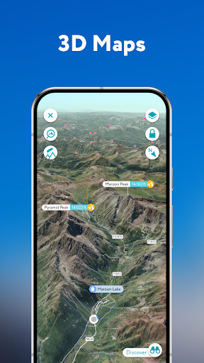
Unleashing the Power of 3D Maps
With PeakVisor, experience high-precision terrain modeling that offers an unprecedented view of mountain landscapes. Our cutting-edge technology creates detailed topographic maps, allowing you to explore and understand the nuances of terrain from the comfort of your device. The intuitive interface enables you to rotate, zoom, and navigate through stunning 3D visualizations, giving you a comprehensive overview of your chosen mountain area. Whether planning a hike or just exploring different terrains, these advanced maps serve as your digital alpine guide.
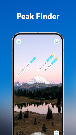
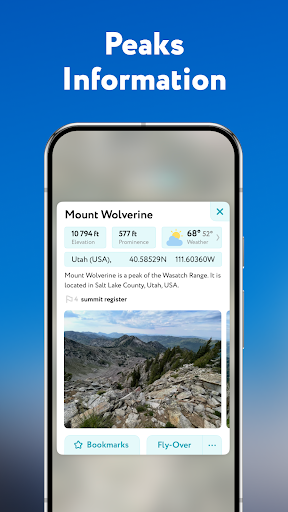
Identify Over a Million Peaks Globally
One of the standout features of PeakVisor is its extensive Peak Identification capability. The app can recognize more than a million mountains, hills, spires, and other landforms worldwide. Simply point your camera towards any peak, and instantly, the app displays vital details such as altitude, topographic prominence, mountain range, and proximity to national parks or reserves. Additionally, it provides photos and links to Wikipedia articles for deeper insights. This feature turns your smartphone into a portable mountain encyclopedia, perfect for explorers and outdoor professionals alike.
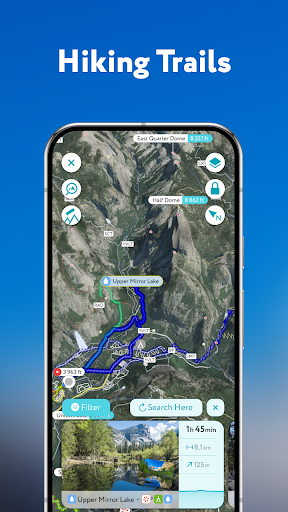
Plan Your Hiking Routes with Confidence
Planning a safe and enjoyable hike is made easier with PeakVisor. The app offers an extensive network of worldwide hiking trails and walking paths overlaid onto detailed 3D Maps. You can evaluate trail distances, elevation profiles, estimated times, and difficulty levels to tailor your adventures. Save your pre-planned routes for offline access, ensuring you're never lost or stranded without guidance. The ability to analyze elevation changes and trail conditions helps both beginners and experienced hikers craft optimal routes for every adventure.
Experience Winter Sports in Detail
During winter, PeakVisor becomes an essential tool for skiers and snowboarders. Its topographic maps visualize terrain features clearly, including mountain lifts, ski resort trails, and backcountry routes. The app also offers specialized features like winter mode and a slope steepness overlay to identify potentially dangerous avalanche terrain. Whether you're navigating ski lifts or exploring remote backcountry areas, this app enhances safety and enjoyment on snow-covered mountains.
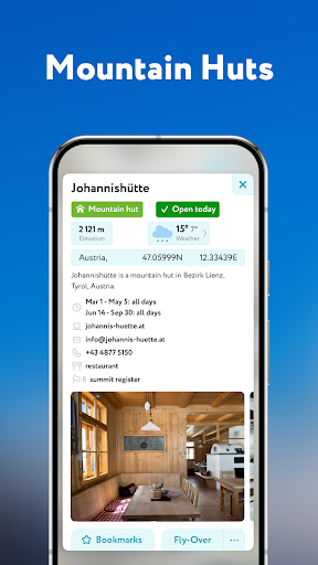
Mountain Culture and Convenience
The app also integrates practical details such as Cable Cars and Mountain Huts, complete with schedules. This becomes invaluable in regions like Europe, where gondolas and cable cars are common. Visiting rustic mountain huts for local cuisine and overnight stays becomes more accessible with these in-built features. PeakVisor helps you embrace mountain culture fully, offering a seamless experience from ascent to rest.
Challenge Yourself with Peak Bagging
Stay motivated with the app's Peak Bagging features, including monthly climbing challenges and competitions. These gamified elements encourage you to explore new summits, achieve personal goals, and share your progress with a community of outdoor lovers. It’s a fun and rewarding way to push your limits and discover new peaks around the world.
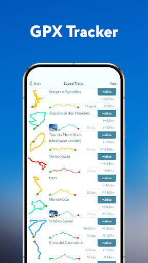
GPS Tracking and Route Exportation
Record all your adventures with the app's comprehensive GPS Tracking. Whether hiking, mountain biking, or backcountry skiing, you can visualize and analyze your routes. After your activity, export the data as a GPX file to review your journey, track stats like total distance and elevation gain, or share with fellow explorers. The ability to document your outdoor experiences adds value and safety to every trip.
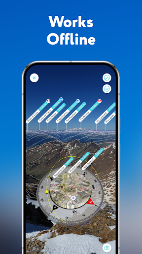
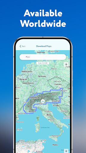
Offline Functionality for Remote Adventures
Perhaps most impressive is that all features of PeakVisor work offline. This means you can access maps, identify peaks, and navigate trails even in the most remote locations without an internet connection. This independence from connectivity ensures you're always prepared, whether ascending remote summits or exploring far-flung wilderness areas.
Conclusion: Your Essential Mountain Tool
In summary, PeakVisor - 3D Maps & Peaks ID elevates outdoor exploration by integrating sophisticated terrain visualization, extensive peak database, route planning, winter navigation tools, and offline capabilities into a single, user-friendly app. It’s a must-have for hikers, skiers, climbers, and outdoor enthusiasts seeking to deepen their understanding of mountain landscapes and stay safe during their adventures. With its robust set of features and immersive visualization, PeakVisor turns your mobile device into a comprehensive mountain guide, making every outdoor trip safer, more informed, and more enjoyable. Whether you’re conquering peaks or exploring local trails, this app is your ideal companion for all mountain pursuits.
Pros
- Detailed 3D mountain maps
- Offline maps available for remote areas
- Peak identification feature
- Augmented reality support
- Extensive global peak database
Cons
- Requires a subscription for full access
- Can drain battery quickly
- Occasional issues with map rendering
- Limited features in the free version
- High data consumption for downloads