Introduction to the US Public Lands App
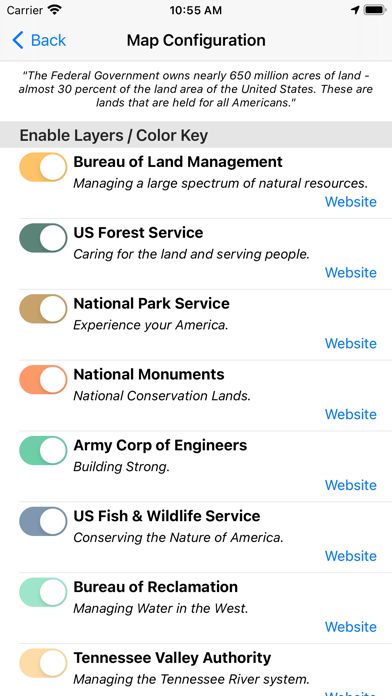
Are you an adventure enthusiast eager to explore the vast wilderness and public lands of the United States? The US Public Lands app is your ultimate digital companion, designed to make navigating and understanding federal lands incredibly accessible and convenient. With nearly 650 million acres of land owned by the US Federal Government, this app unlocks a comprehensive map-based overview of protected areas, national parks, forests, and other federal landholdings. It’s much more than a simple map; it’s a powerful tool that empowers users to easily identify land boundaries, ownership information, and land use regulations, all offline and right at your fingertips. Whether you’re planning a weekend camping trip, a scenic hike, or simply curious about the public lands you encounter, this app provides vital information to enhance your outdoor experience. Its sophisticated layering system, detailed agency data, and GPS features make it a trusted resource for outdoor explorers, adventurers, and nature lovers alike. Discovering the treasures of America’s national parks, wildlife reserves, and public land management areas has never been easier or more portable.
Comprehensive Map Layers for Every Public Land
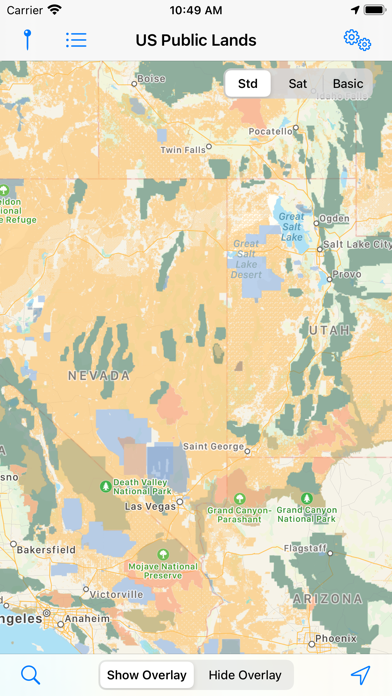
The US Public Lands app includes fully offline map layers that highlight the boundaries and details of federally administered lands. Users can select from beautifully colored, individually selectable layers representing different land management agencies, such as:
- • Bureau of Land Management (BLM)
- • US Forest Service (FS)
- • National Park Service (NPS)
- • Army Corps of Engineers (ACOE)
- • US Fish & Wildlife Service
- • Bureau of Reclamation
- • Tennessee Valley Authority
- • Department of Defense (including military bases and installations)
- • Other public lands (such as national laboratories and test sites)
Key Features and Benefits
The US Public Lands app is packed with features designed to enhance your outdoor adventures:
Offline Accessibility
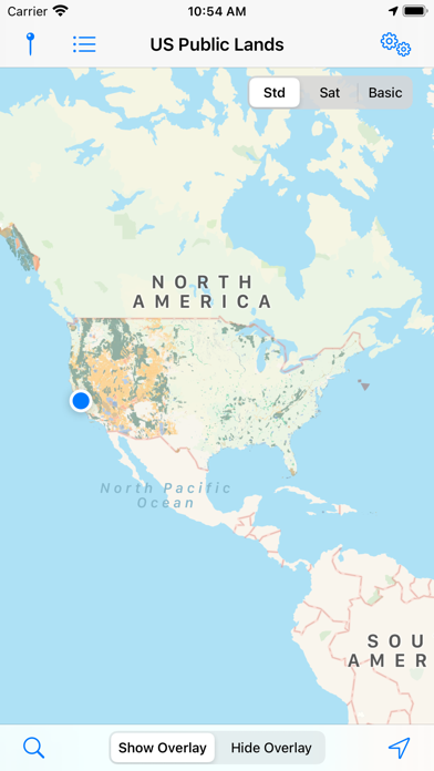
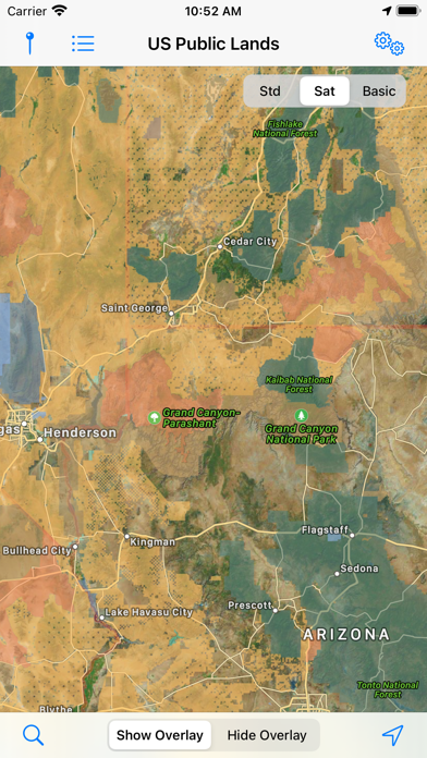
All map layers are stored directly on your device, so there’s no need for an internet connection when exploring remote areas. Turn on the 'Basic' base map to see public land labels on each area, which is also stored offline. When internet access is available, you can switch to standard or satellite view maps for more detailed imagery.
Land Ownership Identification
Easily determine which US agency owns or manages the land around you, ensuring your activities are within legal boundaries, and facilitating responsible recreation.
Exploration and Planning Tools
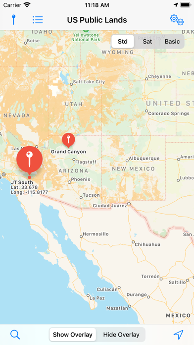
The app acts as a dynamic boondocker’s assistant; while it doesn’t directly list campsites, enabling the satellite view helps scout trails, dispersed camping spots, roads, and signs within public land boundaries. Use the toggle feature to hide or show satellite images for clearer navigation.
Real-Time Location Tracking
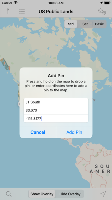
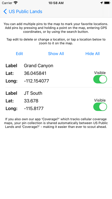
With built-in GPS functionality, tap the 'Locate Me' icon to see your current position instantly, helping you stay within designated public land areas and reinforcing safety.
Search Functionality
The integrated search tool supports location queries like cities, ZIP codes, addresses, and points of interest—provided your device has an internet connection—making trip planning and locating specific sites straightforward.
Data Source and Limitations
The mapping data used in this app is derived from the Protected Area Database (PAD-US) provided by the U.S. Geological Survey. This publicly available, raw map data is invaluable for creating reliable geographic overlays of federal lands across the country. We acknowledge that the data may be subject to updates and corrections over time, so always verify critical information locally—local signage, land management offices, and official resources remain essential for precise boundary knowledge. Remember, there may be private lands or unmapped inholdings within public lands, so always exercise caution and adhere to posted signs.
Why Choose the US Public Lands App?
If you're passionate about exploring America’s vast wilderness, the US Public Lands app offers unmatched convenience and detail. Its offline maps and layered land management data are perfect for backcountry adventures where connectivity is limited. The app is designed with ease of use in mind, providing a user-friendly experience suitable for both seasoned explorers and casual outdoor enthusiasts. Beyond just navigation, it helps foster responsible recreation by informing users about land ownership and regulations, reducing the risk of accidental trespassing or misuse.
Conclusion
In summary, the US Public Lands app is a must-have tool for anyone seeking to connect more deeply with nature while respecting federal land boundaries. It combines detailed, offline maps with interactive features, offering a reliable guide through the countless national parks, forests, and other public lands that make the United States a premier destination for outdoor adventures. Whether planning a trip or exploring last-minute, this app empowers you to navigate confidently, enjoy responsibly, and experience the true beauty of America's public lands.
Pros
- Extensive map coverage.
- Available offline access.
- User-friendly interface design.
- Detailed information on trails.
- Frequent updates provided.
Cons
- Limited features in the free version.
- Requires GPS for precise location.
- Lacks social sharing options.
- Drains battery during extended use.
- Requires in-app purchases for full features.